A GoPro speed overlay drawn from the camera’s own GPS
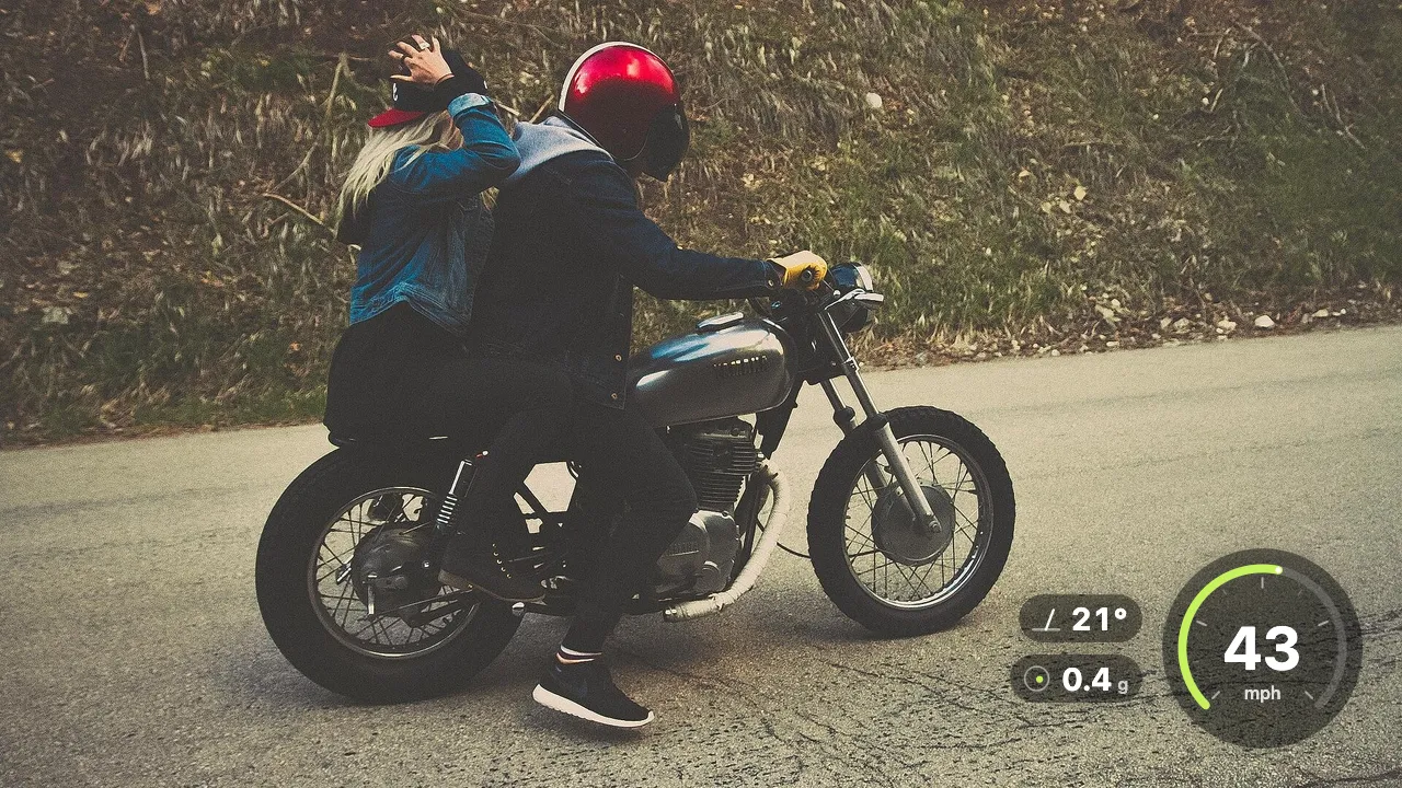
GoPro models with GPS record your speed and position inside every video. Shycut reads that data on your device and draws a speedometer overlay into the footage, with altitude, lean angle and g-force if you want them. Your route is never shown.
Drop your video here
Choose your videoMP4, MOV, WebM or MKV. It opens right here, on your device.
- Nothing uploaded
- No sign-up
- No watermark
How it works
Drop the GoPro video
One file, or all the chapters of a recording. Shycut finds the camera’s GPS data inside the video by itself.
Draw the ride gauge
Turn on “Draw the ride gauge”, choose “Dial” or “Minimal” and pick what it shows: speed, altitude, lean angle, g-force.
Place it and export
Choose a corner, a size and your units, check the preview and save a new MP4 with the gauge drawn in.
What you get
- Data from the camera itself
- GoPro stores GPS in a metadata track inside the MP4, called GPMF. The newer GPS format of recent models is read too. No extra file needed.
- Dial or minimal
- A dial for the classic look, or a minimal readout that keeps more of the picture clear.
- Four values to choose
- Speed, altitude, lean angle and g-force. Show one or all of them, in km/h and metres or mph and feet.
- Ride stats
- Top speed, distance, climb and max lean for the whole ride, shown in the editor next to the gauge settings.
- Honest about gaps
- Where the GPS signal dropped, in a tunnel or before the camera found satellites, the gauge shows dashes instead of guessing.
- Your route stays private
- Only the values are drawn, never the route or coordinates. The gauge switches off inside private places, and location is wiped from the export.
When a speed overlay adds to the story
Motovlogs and mountain passes
Speed and lean tell the story of a twisty road better than a caption. Add the dial and the viewer rides along.
Track days
See where you were fastest and how hard you leaned into each corner, lap after lap, from the same footage.
Cycling climbs and descents
Speed and altitude on the way up and down, with the total climb for the ride in the stats.
Skiing and snowboarding
A helmet GoPro with GPS on a run down the mountain: show the speed and the altitude you dropped.
How the GoPro GPS overlay works, and what it never shows
While it films, a GoPro with GPS records position, speed and altitude several times a second and stores them inside the MP4, in a metadata track called GPMF, right next to the picture and sound. Recent models use a newer GPS format, and Shycut reads both. Because the data travels inside the video file, there is nothing extra to export and no separate app or track file to line up. Drop the video in your browser and the telemetry overlay is ready to switch on.
Speed and altitude come straight from the GPS, smoothed so the numbers don’t jitter. Lean angle and g-force are estimates. From your speed and how quickly your direction changes, Shycut works out the sideways force of a turn and the lean a motorcycle would need to balance it. Real lean also depends on how you sit on the bike and the slope of the road, so read these as a good guide, not a measurement. Units are km/h and metres, or mph and feet.
GPS needs open sky. In a tunnel, under thick trees or just after the camera is switched on, it can lose its fix. Rather than invent numbers, the gauge shows dashes there, and the app tells you how much of the video has no signal. If the camera recorded no position at all, it says so. For the ride as a whole, Shycut also shows top speed, distance, climb and max lean, all worked out from the same data.
A speedometer overlay should not give away where you live. Only the values are drawn; the route and coordinates never appear in the video, and the exported file carries no GPS position. Save places like home or work and the time near them is blurred or cut, with the gauge switched off inside them. If a ride is split into chapters, drop them all: the GPS is read from each one, so the gauge runs from start to end. Other cameras and GPX files are on our roadmap. Only need one long file, without a gauge? Merge the GoPro chapters instead.
Tips for a clean speed gauge
- Turn GPS on in the camera and wait for the GPS icon to settle before you press record, or the start of the ride has no signal.
- “Minimal” suits vertical clips where space is tight; “Dial” fills a corner nicely in a wide 16:9 ride video.
- Put the gauge in a corner away from your captions and from where the action usually happens.
- Treat lean angle and g-force as estimates. They show how hard a turn was, not an exact reading from a sensor.
- Save home as a private place once. The gauge switches off near it, and that part of the ride is blurred or cut.
Private by construction
- Runs on your device
- Your browser decodes, analyses and encodes the video. There is no server to send it to.
- Nothing is uploaded
- The counter in the header measures every byte this page sends. It stays at zero.
- Location data wiped
- Phones hide GPS positions inside videos. The exported file never carries them.
Questions
Which cameras does the GoPro speed overlay work with?
GoPro models with GPS, including those that use the newer GPS format. Other action cameras are not supported yet, and importing GPX files for them is on our roadmap. Any video can still be edited in Shycut without the gauge.
Do I need a separate GPS file or app?
No. A GoPro with GPS turned on stores the data inside the MP4 itself. Shycut reads it in your browser, so the video file is all you need.
How accurate is the lean angle?
It is an estimate. Shycut works out the lean a motorcycle would need for the turn from your speed and change of direction. Your body position and the road’s slope also play a part, so treat it as a guide.
Why does the gauge show dashes?
The GPS lost its signal there, often in a tunnel, under trees or just after the camera was switched on. The gauge shows dashes instead of made-up numbers, and the app tells you how much of the video is affected.
Can people see my route in the video?
No. Only speed, altitude, lean angle and g-force are drawn. The route and coordinates never appear, the gauge switches off inside your private places, and the exported file carries no location data.
Does the gauge work when the ride is split into chapters?
Yes. Drop all the chapter files together. They are joined without re-encoding, and the GPS from each chapter is lined up with the joined video, so the gauge runs from the first minute to the last.
Your video stays with you.
Open Shycut, drop the video in and export. Free, with no account, and your video never leaves your device.
Choose your videoMore free tools
- Blur faces in video
- Pixelate a face
- Blur a moving face
- Blur children’s faces
- Blur license plates
- Dashcam video editor
- Remove location data
- Video metadata viewer
- Check a video’s location
- Remove silences
- Add captions to video
- SRT subtitle generator
- Resize for Reels & TikTok
- Merge videos
- Merge portrait and landscape
- Add music to video
- Speed up video
- Screen recorder
- Motovlog editor
- Merge GoPro videos
- Remove wind noise